Cyclone formation and structure
Cyclone Formation
Stages of Tropical Cyclone
A tropical cyclone can be regarded as a large and tall cylinder of clouds containing enormous amounts of water and packing heavy winds. It is like a giant heat engine fuelled by the release of latent heat due to condensation ty of water vapor drawn from the warm sea surface waters. The released latent heat warms u the air, making the air lighter in that column which more warm and moist air to rise and consequently more release of latent heat over the same place. Thus air rushes in from all sides and rises vertically up creating a rotating vortex. If the process continues for a longer pressure fall in that place could be very much below normal resulting in further growth of the tropical cyclone and strengthening the winds. To get this engine started a large quantity of warm and moist air is required. Steady supply is needed to keep the process going. Scientific studies indicate that this is possible under certain conditions. These conditions are necessary, though not necessarily sufficient, for cyclone formation. These conditions are.
(1): sufficiently large areas of ocean with sea surface temperature around 26-27 degree celsius;
(2): depth of warm water, at least 50 to 60 Meters so that sufficient supply of warm and moist air is ensured.
(3): initial rotation trigger should be provided by some favorable meteorological conditions.
Cyclones continue to gather strength while seawater increasing their speed of movement as well as the wind speed in the rotational field. They normally decay rapidly into a depression after entering the land, and at time4s may continue moving as a depression over the land for a few days giving widespread rainfall but much less wind. Cyclones also die over the ocean by entering a region of cold water or unfavorable meteorological environment even when it is over the ocean.
 |
| Parts of a cyclone formation |
Cyclone Structure
The structure of mature cyclones can be discussed with respect to the shape and strength of the winds. As already stated Tropical Cyclones can be regarded as a large rotating cylindrical mass of the atmosphere extending horizontally from 150-1000 km and vertically from the surface to 12-14 km. Fierce winds spiraling anti-clockwise in the Northern Hemisphere below around the calm cyclone centre of the low-pressure area in the lower level. At higher level, the sense of rotation of wind is just opposite to that of the lower level. In Southern Hemisphere, the sense of rotation of the wind is opposite that in the NH. The entire cyclonic storm generally moves 250-500 km per day (10-20 kmph) over the ocean, This is is the speed of movement of the cyclone. On the other hand, wind sped within such a cyclone can be as high as 200-250 kmph. Destination between the 'Speed of the Cyclone' and 'Wind speed in a cyclone' should, which is the main destructive feature of a cyclone.
As already mentioned, a cyclone starts as a low-pressure through different stages of its development and intensification. The classification of these stages as followed in India is given below.
 |
| Formation and structure of a cyclone |
| categories (Weather Systems) Abbreviations used | Wind Speed 1 knot = 1.852km |
| 1.Low-Pressure Areas 2.Depression 3.Deep Depression 4.Cyclonic Storm 5.Severe Cyclonic Storm 6.Very Severe Cyclonic Storm 7.Super Cyclonic Storm | <17 knots 17 to 27 knots 28 to 33 knots 34 to 47 knots 48 to 63 knots 64 to 119 knots More than 119 knots |
It is evident from the table that the cyclone's wind speed has been classified in seven categories, which rages from less than 17 knot to super cyclone storm with wind speed of more than 119 knots.
It is natural that in a cyclone extending about 1000 km horizontally and 12 km vertically, the wind speed will not be the same throughout. It is highly variable wind field. The wind field in a cyclone can be discussed in terms of its horizontal and vertical distribution. Horizontally, the wind field in a cyclone can be divided into three major zones.
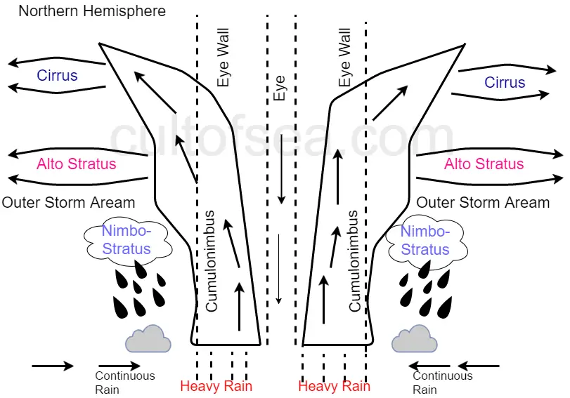
(1) the central area as 'Eye" with an average radius of 20-30 km. with calm or very little wind.
(2)followed outwards by a narrow zone of 15-20 km. wide surrounding the eye known as Zone of Maximum Wind or Wall Cloud Zone where the wind speed in maximum.
(3) The zone followed thereafter known as Outer Wind Zone extending up to 300 to 500 km. from the center where wind speed is gradually decreased with distance. Vertically, wind field can also be divided into three-zone namely.
(1) Inflow Layer
(2) Middle Layer
(3) Outflow Layer
As stated above. the eye of the tropical cyclone is almost cloud-free, surrounded by the wall of the clouds known as the Wall Cloud Zone. This wall cloud zone coincides with the zone of the maximum wind. Thus this zone, though very narrow, constitutes the most hazardous zone of a tropical cyclone, as winds here are extremely strong. rainfall is very heavy, the vertical velocity is large and the convective clouds arranged in the form of a wall are very tall. Clouds outside the wall cloud are arranged in bands and finally, these bands merge with the wall cloud zone surrounding the central portion of the cyclone.


Comments
Post a Comment